


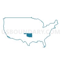
Southeast Oklahoma PUMA, Oklahoma
About
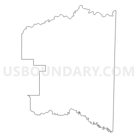
Outline
Summary
| Unique Area Identifier | 193782 |
| Name | Southeast Oklahoma PUMA |
| State | Oklahoma |
| Area (square miles) | 8,465.54 |
| Land Area (square miles) | 8,209.47 |
| Water Area (square miles) | 256.07 |
| % of Land Area | 96.98 |
| % of Water Area | 3.02 |
| Latitude of the Internal Point | 34.58949830 |
| Longtitude of the Internal Point | -95.13498410 |
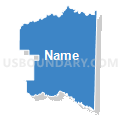
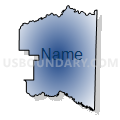
Maps

Graphs
Select a template below for downloading or customizing gragh for Southeast Oklahoma PUMA, Oklahoma


Neighbors
Neighoring Public Use Microdata Area (by Name) Neighboring Public Use Microdata Area on the Map
- Ark-Tex COG (East)--Bowie & Cass Counties PUMA, TX
- Ark-Tex COG (West) PUMA, TX
- Bryan, Pontotoc (East), Marshall, Atoka, Johnston & Coal Counties--Ada City PUMA, OK
- Cherokee, Sequoyah & Adair Counties PUMA, OK
- Logan, Polk, Franklin, Sevier, Howard & Scott Counties PUMA, AR
- Muskogee, Okmulgee, Wagoner (East) & McIntosh Counties PUMA, OK
- Payne, Seminole, Creek (Southwest), Hughes & Okfuskee Counties--Stillwater City PUMA, OK
- Sebastian & Crawford Counties PUMA, AR
- Southwest Arkansas PUMA, AR
Top 10 Neighboring County (by Population) Neighboring County on the Map
- Sebastian County, AR (125,744)
- Bowie County, TX (92,565)
- Muskogee County, OK (70,990)
- Le Flore County, OK (50,384)
- Lamar County, TX (49,793)
- Pittsburg County, OK (45,837)
- Bryan County, OK (42,416)
- Sequoyah County, OK (42,391)
- McCurtain County, OK (33,151)
- Polk County, AR (20,662)
Top 10 Neighboring County Subdivision (by Population) Neighboring County Subdivision on the Map
- Upper township, Sebastian County, AR (76,938)
- McAlester CCD, Pittsburg County, OK (26,311)
- Checotah CCD, McIntosh County, OK (11,779)
- Broken Bow CCD, McCurtain County, OK (11,591)
- Muldrow CCD, Sequoyah County, OK (10,626)
- Idabel CCD, McCurtain County, OK (10,011)
- Roland CCD, Sequoyah County, OK (9,632)
- Heavener CCD, Le Flore County, OK (9,315)
- Hugo CCD, Choctaw County, OK (9,218)
- Central Atoka CCD, Atoka County, OK (8,959)
Top 10 Neighboring Place (by Population) Neighboring Place on the Map
- Fort Smith city, AR (86,209)
- McAlester city, OK (18,383)
- Poteau city, OK (8,520)
- Idabel city, OK (7,010)
- Hugo city, OK (5,310)
- Broken Bow city, OK (4,120)
- Pocola town, OK (4,056)
- Heavener city, OK (3,414)
- Wilburton city, OK (2,843)
- Longtown CDP, OK (2,739)
Top 10 Neighboring Elementary School District (by Population) Neighboring Elementary School District on the Map
- Krebs Public School, OK (2,986)
- Hodgen Public School, OK (1,747)
- Frink-Chambers Public School, OK (1,710)
- Farris Public School, OK (1,576)
- Denison Public School, OK (1,465)
- Holly Creek Public School, OK (1,433)
- Haywood Public School, OK (1,286)
- Lukfata Public School, OK (1,254)
- Lane Public School, OK (1,178)
- Monroe Public School, OK (1,138)
Top 10 Neighboring Unified School District (by Population) Neighboring Unified School District on the Map
- Fort Smith Public Schools, AR (89,450)
- Greenwood School District, AR (19,838)
- McAlester Public Schools, OK (18,175)
- North Lamar Independent School District, TX (17,014)
- Mena Public Schools, AR (13,335)
- Sallisaw Public Schools, OK (12,287)
- Poteau Public Schools, OK (11,094)
- De Queen School District, AR (11,059)
- Checotah Public Schools, OK (10,336)
- Waldron School District, AR (9,473)
Top 10 Neighboring State Legislative District Lower Chamber (by Population) Neighboring State Legislative District Lower Chamber on the Map
- State House District 1, TX (146,509)
- State House District 3, TX (145,984)
- State House District 21, OK (39,709)
- State House District 2, OK (37,808)
- State House District 17, OK (36,307)
- State House District 18, OK (35,558)
- State House District 20, OK (35,429)
- State House District 3, OK (35,355)
- State House District 15, OK (35,338)
- State House District 24, OK (35,109)
Top 10 Neighboring State Legislative District Upper Chamber (by Population) Neighboring State Legislative District Upper Chamber on the Map
- State Senate District 1, TX (731,108)
- State Senate District 6, AR (89,072)
- State Senate District 13, AR (82,857)
- State Senate District 6, OK (79,973)
- State Senate District 4, OK (78,222)
- State Senate District 8, OK (75,663)
- State Senate District 9, OK (75,370)
- State Senate District 21, AR (74,633)
- State Senate District 7, OK (73,650)
- State Senate District 20, AR (73,443)
Top 10 Neighboring 111th Congressional District (by Population) Neighboring 111th Congressional District on the Map
- Congressional District 4, TX (846,142)
- Congressional District 3, AR (822,564)
- Congressional District 2, OK (729,887)
- Congressional District 4, AR (654,283)
Top 10 Neighboring Census Tract (by Population) Neighboring Census Tract on the Map
- Census Tract 13.04, Sebastian County, AR (7,309)
- Census Tract 103.02, Sebastian County, AR (6,882)
- Census Tract 15, Muskogee County, OK (6,699)
- Census Tract 304.02, Sequoyah County, OK (6,617)
- Census Tract 13.03, Sebastian County, AR (6,555)
- Census Tract 403.01, Le Flore County, OK (6,116)
- Census Tract 103.01, Sebastian County, AR (6,086)
- Census Tract 985, McCurtain County, OK (5,972)
- Census Tract 872, Latimer County, OK (5,960)
- Census Tract 977, Pushmataha County, OK (5,892)
Top 10 Neighboring 5-Digit ZIP Code Tabulation Area (by Population) Neighboring 5-Digit ZIP Code Tabulation Area on the Map
- 74501, OK (29,073)
- 72901, AR (21,591)
- 74955, OK (15,344)
- 71953, AR (14,882)
- 72908, AR (13,378)
- 74948, OK (12,788)
- 74953, OK (11,632)
- 74728, OK (11,343)
- 71832, AR (11,253)
- 74525, OK (10,112)